


Kevin Jeanes has the latest forecast update for the Chicago area.
A fast-moving line of storms is set to make its way into the Chicago area late Friday, bringing the first severe weather threat of the year to the region, with multiple hazards possible.
The threat follows what will largely be a beautiful, summer-like day in Chicago.
Highs will reach near 80 degrees for many with sunny and windy conditions expected for most of the day.
Wind gusts are slated to pick up starting in the afternoon hours Friday, as the National Weather Service forecasts a large and powerful storm system for northern Illinois between Friday night and Saturday morning.
"A line of strong to severe thunderstorms will move across the area late this evening and stretch into tonight. These storms will be capable of producing destructive winds with a few brief tornadoes also possible," the NWS tweeted.
While the timing of the storms continues to develop as the system nears, latest projections put the system arriving on the western edge of the Chicago area by 10 p.m. Friday and continuing to move across the region until as late as 2 a.m. Saturday.
Here’s a look at individual severe weather threats and timing windows tonight as a quickly-moving line of storms sweeps through. Ensure you have multiple ways to receive warnings, including ones that will wake you up. #ILwx #INwx pic.twitter.com/k1Twh37L5q
— NWS Chicago (@NWSChicago) March 14, 2025
Local


Once arrived, storms are expected to last one-to-two hours, though the larger threat for damaging winds sits on the front edge of the system.
While the highest threat for more severe outcomes remains just outside the Chicago area, NBC 5 Storm Team Meteorologist Kevin Jeanes said the developing situation could still bring increased risks to the Chicago area.
Feeling out of the loop? We'll catch you up on the Chicago news you need to know. Sign up for the weekly Chicago Catch-Up newsletter.
"It's just a question of how much [the storms] weaken going into the night," Jeanes said, noting that it is a "line of storms we're going to be watching very closely."
Parts of the Chicago area sit under an "enhanced" threat for severe conditions, a level three of five, while others are under a "slight" risk, or a level two of five.
The enhanced risk is forecasted for much of LaSalle and Kendall counties, as well as southwestern Will County and the western half of Kankakee County.
"If this line does hold together you have the threat of damaging wind gusts and weak tornadoes," Jeanes said.
The threat for tornadoes is highest on a line southwest of Rockford to Paxton.
"Ensure you have multiple ways to receive warnings, including ones that will wake you up," the NWS warned.
Jeanes agreed.
"It's a good time to make sure that you're ready for severe storms," he said.
Get Chicago weather updates on the NBC Chicago news app. Subscribe to push alerts for the latest weather updates.
Beyond the evening storms, the high winds Friday aren't expected to be entirely harmless, with anticipated warm temperatures and dry vegetation creating favorable fire conditions. A red flag warning is in effect for several hours Friday in multiple counties.
The National Weather Service's Chicago office advises residents to secure loose objects and limit outdoor burning.
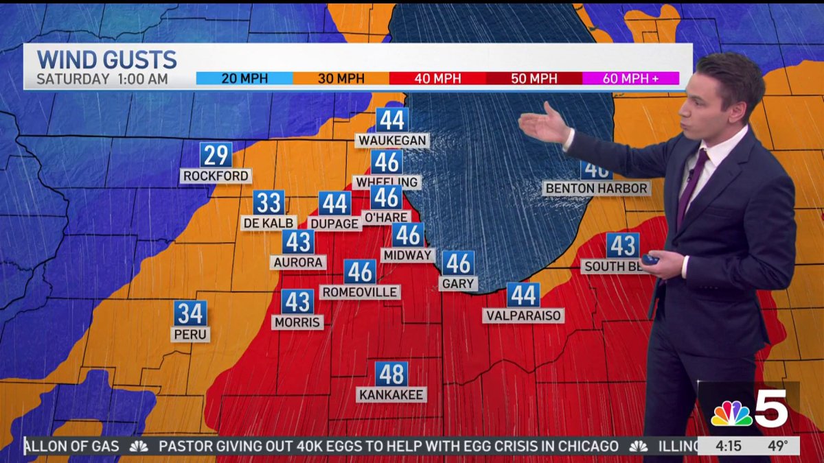
Wind advisories and high wind warnings have been issued across the Chicago area both Friday and Saturday.
The advisory continues throughout Friday and until 7 a.m. CT Saturday. At that time, a high wind warning takes effect and continues until 12 p.m. Another advisory then begins at noon and continues until 5 p.m.
The alerts warn of gusts of up to 50 mph during the advisory, and possibly even as high as 60 mph during the warning.
While storms will then move out of the area, the high wind watch will be in effect as thousands of people are expected to watch the Chicago River be dyed green for St. Patrick's Day.
Though high temperatures near 70 degrees are expected, wind gusts over 50 miles per hour are possible, with the high wind watch remaining in effect until 3 p.m. Saturday.
From there, a swift and drastic cooldown is expected, with high temperatures likely to only reach the mid 40s on Sunday.

