Editor's note: Find the latest updates on the approaching snowstorm here.
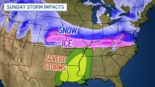
Snow, ice and potentially severe weather are slated to hit parts of the Midwest this week, but there will likely be a sharp cut-off line for snow when the system hits.
According to NBC 5 Storm Team Meteorologist Kevin Jeanes, "there will be a sharp gradient of significantly lower totals on the northern edge" of the system. For those on the southern edge, ice and potentially severe weather are more likely.
The major winter storm system is set to move across the Central Plains this weekend, dumping heavy snow in parts of Illinois early Sunday, with "big impacts" downstate, Jeanes said.
Current forecast models show as much as six to eight inches of snow south of I-74, Jeanes said. Further south, a wintry mix of ice and snow is likely, he added.
If the storm tracks further north, it could clip parts of the Chicago area Sunday into Monday.
"There is a set of models keeping the system completely south of the Chicago area, and another set of models bringing up to 3 inches of snow for us; with more snow for the Kankakee River valley," Jeanes said.
Map of the winter storm forecast
So where can you expect the most snow?
Here's a look at the latest projects, as of early Friday morning:
Feeling out of the loop? We'll catch you up on the Chicago news you need to know. Sign up for the weekly> Chicago Catch-Up newsletter.

In St. Louis, the National Weather Service warned of hazardous weekend travel conditions associated with the storm, with snow-covered roads and freezing rain possible.
"Travel should be avoided Sunday, if at all possible" the NWS said.
❄️🧊A range of winter precipitation types are expected across the region late Saturday, Sunday & early Monday. Details are expected to become clearer thru the day today. Travel should be avoided Sunday, if at all possible. #mowx #ilwx #stlwx #midmowx pic.twitter.com/CRhVDmXgL2
— NWS St. Louis (@NWSStLouis) January 3, 2025
The winter storm will also impact Indiana, with a winter storm watch issued beginning 1 p.m. Sunday along and south of US 24.
"Accumulating snow and travel impacts are likely," the NWS said, with the storm likely to threaten the Monday morning commute.
While uncertainty remained regarding the timing and location of the storm track, the latest storm forecasts call for heavy snow and ice across much of the Midwest through Tuesday, including Missouri, Illinois and Indiana.
"Expect potentially dangerous travel conditions in some locations," the NWS said.
Here are the latest Key Messages for the winter storm set to produce significant snow & ice accumulations from the Central Plains to the Mid-Atlantic this weekend & into early next week. Expect potentially dangerous travel conditions in some locations. pic.twitter.com/cRieD6hKpF
— NWS Weather Prediction Center (@NWSWPC) January 2, 2025
The most likely outcome for the Chicago area will be more localized lake effect snow coming off of Lake Michigan, with one to three inches of snow possible in some parts.


