
You’re watching the NBC 5 Chicago News streaming channel, which plays local Chicago news 24 hours a day, seven days a week. You can find the “NBC 5 Chicago News” streaming channel on your phone or computer, and on Peacock, Samsung, Roku, Xumo or on our app, so you can watch our local news on your schedule.
Chicago-area residents are likely to feel a blast of summer alongside windy conditions and a good dose of sunshine during the day on Friday, but that will quickly turn to the region's first chance for severe weather this year.
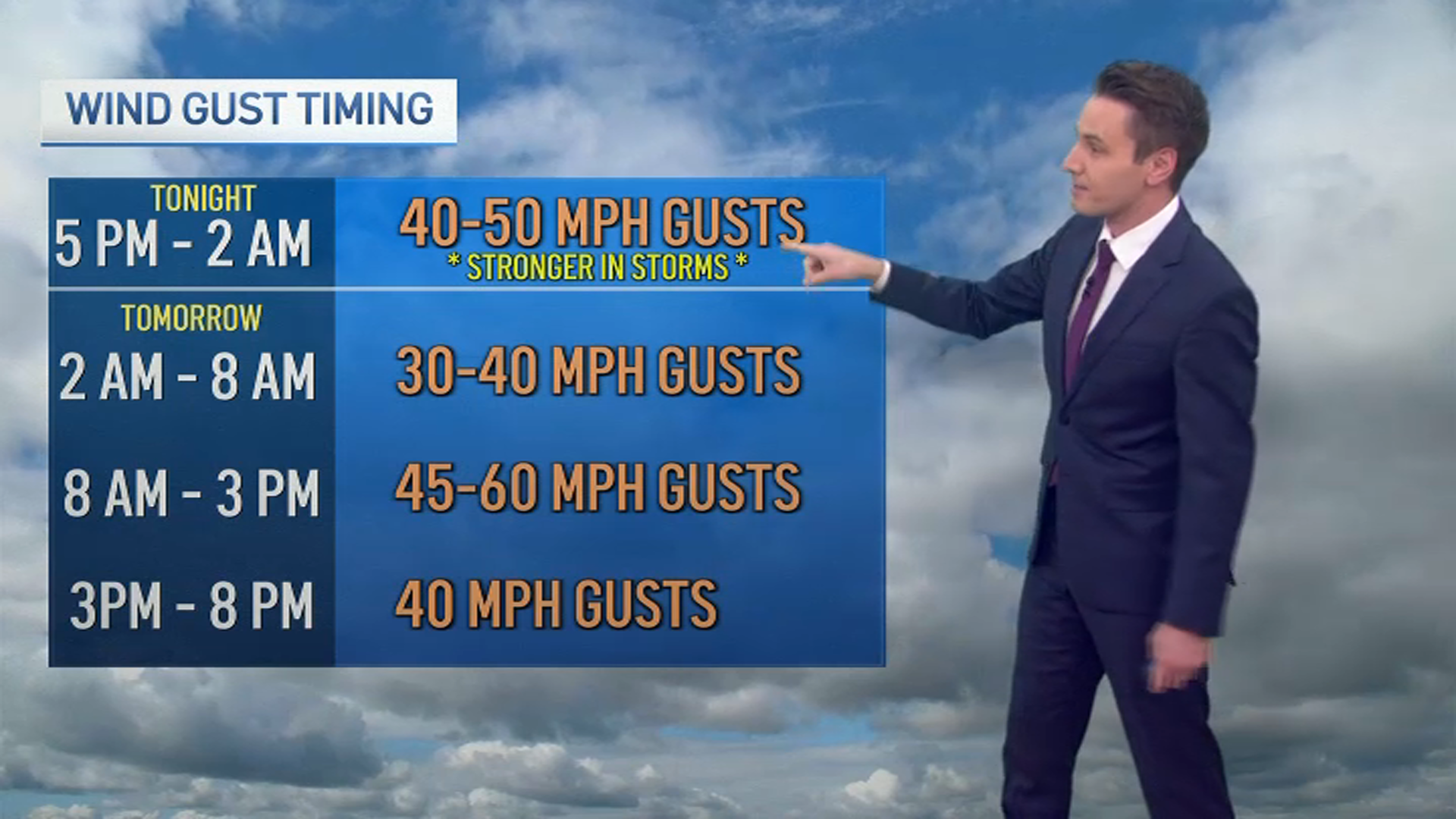
Temperatures could reach into the high 70s in parts of the Chicago area Friday, with winds of 15 to 25 miles per hour expected and higher wind gusts possible.
The mercury is expected to rise rather quickly, with clouds clearing and temperatures rising rapidly from the mid-morning into the late afternoon, when Chicago will likely see its daily high temperature recorded.
The high winds of Friday aren't expected to be entirely harmless, with anticipated warm temperatures and dry vegetation throughout the region creating favorable fire conditions.
The National Weather Service's Chicago office advises residents to secure loose objects and limit outdoor burning.
From there, a fast-moving line of storms will approach the region from the southwest, with the greatest likelihood for severe weather occurring in the far southwest reaches of the region, such as far southwestern LaSalle County.
An enhanced risk of severe weather is forecasted for much of LaSalle and Kendall counties, as well as southwestern Will County and the western half of Kankakee County.
Local
(2) A fast-moving line of storms will sweep across our area Friday night with a threat for damaging winds and tornadoes. The highest threat will be across central Illinois, but may very well continue to the Lake Michigan shoreline. #ILwx #INwx pic.twitter.com/6KmkvnNsiX
— NWS Chicago (@NWSChicago) March 13, 2025
Chicago and much of the metropolitan area is at a slight risk of severe weather late Friday evening into early Saturday morning, with hazards of destructive winds and tornadoes in play.
Feeling out of the loop? We'll catch you up on the Chicago news you need to know. Sign up for the weekly Chicago Catch-Up newsletter.
While Cook County and northwest Indiana likely won't see the storm approach until around 10 p.m., the far west parts of the area could see storms move in as early as 8 p.m.
West suburban counties such as Kane, Kendall, Grundy and much of Will are likely to see storms move in by 9 p.m., with the rest of the area expected to see storms begin by 10 p.m.
Once arrived, storms are expected to last three-to-four hours, making the system a likely overnight event.
Weather officials cite damaging winds as the primary threat across the area, though a tornado risk is certainly present, especially in areas from southwest of Rockford to Paxton, located in Iroquois County.
(3) Friday night is the first time this year our area is in a threat for severe weather. Ensure you have multiple ways to receive warnings, including one way to wake you up in the middle of the night. Here's a look at storm time windows across our area: #ILwx #INwx pic.twitter.com/MEECrFrJK5
— NWS Chicago (@NWSChicago) March 13, 2025
While storms will then move out of the area, warm temperatures and gusty winds will stick around, with a high wind watch in effect for Saturday as thousands of people are expected to watch the Chicago River be dyed green for St. Patrick's Day.
Though high temperatures near 70 degrees are expected, wind gusts over 50 miles per hour are possible, with the high wind watch remaining in effect until 3 p.m. Saturday.
From there, a swift and drastic cooldown is expected, with high temperatures likely to only reach the mid 40s on Sunday.