


Possibly severe storms and dangerous winds are approaching the Chicago area, with high winds persisting through Saturday.
What started as a summer-like day Friday will end with potentially severe storms as a powerful system prepares to sweep across the region, but there's a narrow window of time you'll want to make sure you're prepared for.
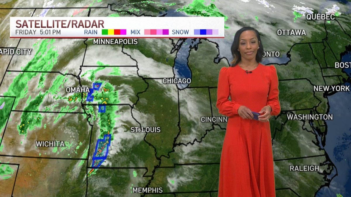
The fast-moving line of storms is set to make its way into the Chicago area late Friday, bringing the first severe weather threat of the year to the region, with the potential for wind gusts of up to 70 mph and possible tornadoes, according to the NBC 5 Storm Team.
At around 7 p.m., the National Weather Service issued a severe thunderstorm watch for the entire Chicago area outside of northwest Indiana until 2 a.m., with wind and isolated tornadoes the primary threat.
A severe thunderstorm watch has been issued for portions of northern and northeast IL until 2 AM CDT. Note storms are still 3-4 hours away, but now is the time to begin monitoring the weather and make sure your prepared including have multiple ways to get warnings! #ILwx https://t.co/HczztijY9s
— NWS Chicago (@NWSChicago) March 14, 2025
Here's what to look out for:
Wind advisory and red flag warning
Wind advisories and high wind warnings have been issued across the Chicago area both Friday and Saturday.
Local

The advisory continues throughout Friday and until 7 a.m. CT Saturday. At that time, a high wind warning takes effect and continues until 12 p.m. Another advisory then begins at noon and continues until 5 p.m.
The alerts warn of gusts of up to 50 mph during the advisory, and possibly even as high as 60 mph during the warning.
Feeling out of the loop? We'll catch you up on the Chicago news you need to know. Sign up for the weekly Chicago Catch-Up newsletter.
A red flag warning also began in multiple counties late Friday morning.
The warning is in effect through 12 a.m. CT Saturday in the following counties:
- McHenry
- DeKalb
- Kane
- DuPage
- LaSalle
- Kendall
- Grundy
- Will
- Kankakee
- Lake
- Cook
Friday evening
"A line of strong to severe thunderstorms will move across the area late this evening and stretch into tonight. These storms will be capable of producing destructive winds with a few brief tornadoes also possible," the NWS tweeted.
10 p.m. - 12 a.m.
While the timing of the storms continues to develop as the system nears, latest projections put the system arriving on the western edge of the Chicago area by 10 p.m. Friday.
Here’s a look at individual severe weather threats and timing windows tonight as a quickly-moving line of storms sweeps through. Ensure you have multiple ways to receive warnings, including ones that will wake you up. #ILwx #INwx pic.twitter.com/k1Twh37L5q
— NWS Chicago (@NWSChicago) March 14, 2025
Once arrived, storms are expected to last one-to-two hours, though the larger threat for damaging winds sits on the front edge of the system.
While the highest threat for more severe outcomes remains just outside the Chicago area, NBC 5 Storm Team Meteorologist Kevin Jeanes said the developing situation could still bring increased risks to the Chicago area.
"It's just a question of how much [the storms] weaken going into the night," Jeanes said, noting that it is a "line of storms we're going to be watching very closely."
The threat for tornadoes is highest on a line southwest of Rockford to Paxton.
"If this line does hold together you have the threat of damaging wind gusts and weak tornadoes," Jeanes said.
The Chicago area sits under an "enhanced" threat for severe conditions, a level three of five.
"Severe weather is expected tonight with much of our area in a Level 3 or Level 4 threat level. Damaging winds strong enough to bring down trees are the main threat, though a tornado or two may occur as well," the NWS reported.
Overnight and into Saturday morning
Forecasters warn the storms could continue to move across the region until as late as 2 a.m. Saturday.
"Ensure you have multiple ways to receive warnings, including ones that will wake you up," the NWS warned.
Jeanes agreed.
"It's a good time to make sure that you're ready for severe storms," he said.
Get Chicago weather updates on the NBC Chicago news app. Subscribe to push alerts for the latest weather updates.
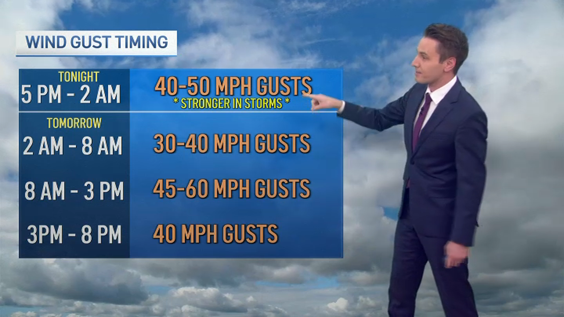
Saturday morning and afternoon
While storms will then move out of the area, a high wind watch will be in effect as thousands of people are expected to watch the Chicago River be dyed green for St. Patrick's Day.
The wind watch will be in effect Saturday morning through the afternoon. The watch warns of gusts of up to 60 mph continuing through 3 p.m. Saturday.
High temperatures near 70 degrees are expected.
Sunday
A swift and drastic cooldown is expected Sunday, with high temperatures likely to only reach the mid 40s.
There is a chance for showers Sunday, with partly cloudy skies expected.

