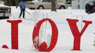
A white Christmas seems to be slowly morphing from a reliable reality to a dream of snowy holidays past for large swaths of the United States in recent decades.
Analysis of 40 years of December 25 U.S. snow measurements shows that less of the country now has snow for Christmas than in the 1980s.
That's especially true in a belt across the nation’s midsection — from Baltimore to Denver and a few hundred miles farther north. And snow that falls doesn’t measure up to past depths.
Scientists say the decline in the number of white Christmases is relatively small and caution about drawing conclusions. But it’s noticeable and matters mightily to some people like George Holland.
The retired Dubuque, Iowa, educator known for his front yard nativity scenes said snow on Christmas is supposed to be part of the holiday: “The one that makes my heart warm is after going to midnight Mass and coming outside and it's snowing.”
But the weather in Dubuque hasn't cooperated in recent years. “We don’t have white Christmas,'' said boutique owner Bill Kaesbauer. "We haven’t had any in years.”
The last one was in 2017 in Dubuque, which weather records show used to have white Christmases nearly two out of three years.
Changing Climate
In-depth coverage of our changing climate and environmental issues
The average December temperature in the continental U.S. was a tad below freezing from 1981 to 1990, federal weather records show. And from 2011 to 2020, it was up to an average slightly above 35 degrees (just under 2 degrees Celsius), considerably above the freezing mark.
But what did that warming trend, natural weather variability and a western megadrought mean to white Christmases?
Feeling out of the loop? We'll catch you up on the Chicago news you need to know. Sign up for the weekly Chicago Catch-Up newsletter.
From 1981 to 1990, on average, almost 47% of the country had snow on the ground Christmas Day, with an average depth of 3.5 inches (8.8 centimeters), according to an analysis of ground observation data by the University of Arizona for The Associated Press. From 2011 to 2020, Christmas snow cover was down to 38%, with an average depth of 2.7 inches (6.8 centimeters).
The change was particularly pronounced in a swath from about the Mason-Dixon line to just north of Detroit, Chicago, and Nebraska. The Christmas snow cover average there went from nearly 55% in the 1980s to slightly above 41% now, the Arizona data shows. Average snow depth fell from 3.5 inches (8.8 centimeters) to 2.4 inches (6 centimeters).
The numbers are small enough that it's difficult to tell whether this is a meaningful trend and, if so, whether climate change or natural weather variability is the cause, said University of Arizona atmospheric scientist Xubin Zeng, who ran the data.
Still, Zeng, who has published studies on decreasing snowpack in the western U.S. being connected to climate change, said the downward slide of white Christmases is consistent with global warming.
In 20 to 30 years “with climate warming, the prospects of a white Christmas in many parts of the U.S.A. will be slim indeed,” said Mark Serreze, director of the National Snow and Ice Data Center in Boulder, Colorado.
A separate analysisby the National Oceanic and Atmospheric Administration looks at “climate normals” — 30-year periods for about 5,000 weather stations across the lower 48 states. Comparing normals for 1981-2010 to normals for 1991-2020 shows more stations are seeing statistical odds for a white Christmas shrink, but the agency cautions against drawing a conclusion about any trend.
In much of Iowa and eastern Washington, the changes are bigger than elsewhere, according to NOAA. From 1981 to 2010, Dubuque’s chance for a white Christmas was 63% but it’s now down to 42%. Walla Walla, Washington’s chance of getting a white Christmas dropped in half from 19% in 1981 to 2010 to 9.5% now.
Denver’s airport station went from 40% chance of Christmas snow from 1981 to 2010 to 34%. Chicago, St. Louis, Kansas City, Salt Lake City, Milwaukee, Fort Wayne, Topeka, Des Moines, Akron, Albany, Olympia, Rapid City, and Oklahoma City airports saw drops of three or four percentage points.
The line where there’s at least a 10% chance for a white Christmas moved noticeably north with the new normals, said NOAA climate scientist Imke Durre. And the nation’s capital went from 10% to 7%.
“The movement of that line is consistent with a warmer December,” Durre said.
New York, Philadelphia and Concord, New Hampshire, recorded small increases in chances of Christmas snow on the ground.
A data set from Rutgers University’s global snow lab finds continental U.S. snow in the last week of December slightly increasing, not decreasing, said climate scientist David Robinson, whose data based on satellite imagery goes back to 1966.
“There’s no trend. You just don’t see it,” Robinson said.
Often people in their 60s and 70s think there are fewer white Christmases, he added, because the 1960s had more than usual white Christmases.
Temperature alters snowfall in two different ways. In warmer borderline areas, warmer air turns snow into rain. But in cooler more northern areas where even higher temperatures are still below freezing, warmer temperatures mean more snow because warmer air holds more moisture, which comes down as snow, meteorologists said.
Several meteorologists cautioned about finding trends in complex data where both precipitation and temperature are factors. But despite those issues, fewer white Christmases seems associated with warmer temperatures from climate change, said Northern Illinois University meteorology professor Victor Gensini.
“It matters for many as an emotional weight of how the season ought to feel or how we think it ought to feel,” National Snow and Ice Data scientist Twila Moon said. “But the climate scientist in me is also very interested in having a white Christmas because it’s an indicator of how much and what type of precipitation we’ve gotten. And that is also really important because so much of our country is dealing with extreme drought right now.”
In Helena, Montana, “it definitely feels like we don’t have as much snow or the winters are different," said Shawn Whyte on Tuesday as the high hit 52 (11 Celsius). “I’m looking out my window right now and I have a lovely view of the entire hill in a valley and it is brown. It’s ugly and brown.
“For us here, we expect winter and cold and it makes you feel snuggly and cozy,” said Whyte, an information technology manager who said she's having trouble getting her Christmas spirit with no snow.
Maybe, she said, if she just goes caroling it will be like a Hallmark movie and the Christmas snow will come at the last minute.
The Associated Press Health and Science Department receives support from the Howard Hughes Medical Institute’s Department of Science Education. The AP is solely responsible for all content.


