Track the fires live in the radar feed above or below
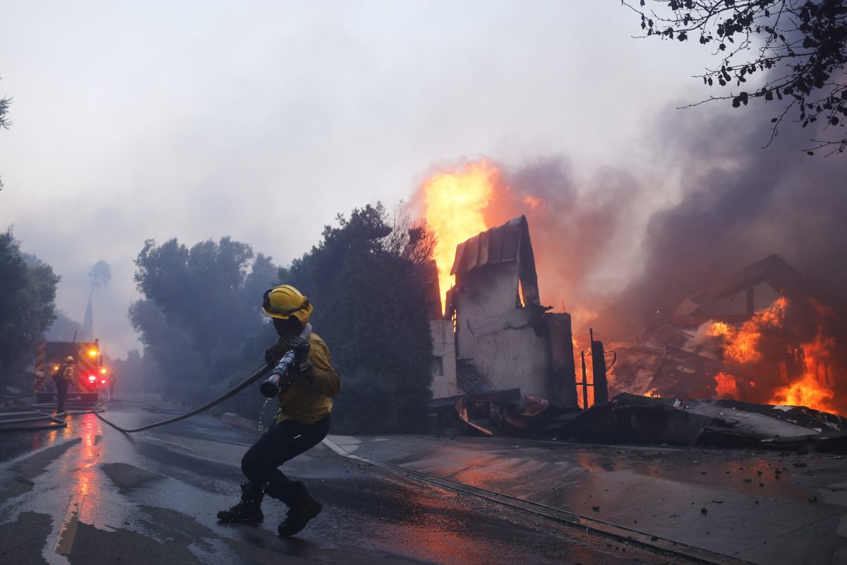
Fierce wildfires are raging in the Los Angeles area, fueled by powerful Santa Ana winds, sending residents fleeing from burning homes through flames, ferocious winds and towering clouds of smoke. Thousands of firefighters were battling at least three separate blazes on Wednesday, from the Pacific Coast inland to Pasadena.
Officials have said about 30,000 residents are under evacuation orders. And more than 13,000 structures are under threat.
The evacuation orders affect areas including the Pacific Palisades neighborhood near the sea, areas north of Pasadena and part of the San Fernando Valley.
Other areas are under evacuation warnings that say people who need additional time to evacuate should get moving.
Los Angeles County Fire Chief Anthony Marrone said two people were killed and many others hurt in the fires, which have destroyed more than 1,000 structures.
Track the fires live in the radar feed above or below.
Where are the California wildfires burning?
The Palisades Fire, which started around 10:30 a.m. Tuesday, had burned about 4.5 square miles, according to officials.
Feeling out of the loop? We'll catch you up on the Chicago news you need to know. Sign up for the weekly Chicago Catch-Up newsletter.
It rained flaming embers onto trees and rooftops in the Pacific Palisades neighborhood. Residents rushing to escape created a traffic jam on Palisades Drive, blocking emergency vehicles from getting through. Crews used a bulldozer to push the abandoned cars off to the side.
The traffic jam on Palisades Drive prevented emergency vehicles from getting through and a bulldozer was brought in to push the abandoned cars to the side and create a path. Video along the Pacific Coast Highway showed widespread destruction of homes and businesses along the famed roadway.
The Eaton Fire, north of Pasadena in the Altadena area, which started around 6:30 p.m. Tuesday, quickly burned 1.6 square miles by early Wednesday according to fire officials.
The flames from that fire, which broke out near a nature preserve in the inland foothills northeast of LA, spread so rapidly that staff at a senior living center had to push dozens of residents in wheelchairs and hospital beds down the street to a parking lot. The residents waited there in their bedclothes as embers fell around them until ambulances, buses and even construction vans arrived to take them to safety.
The Hurst Fire started around 10:30 p.m. Tuesday and prompted evacuations in Sylmar, a San Fernando Valley community in the northernmost neighborhood in Los Angeles. That fire had grown to 500 acres by early Wednesday.
The Tyler Fire in Coachella was relatively small, burning 15 acres.
Images: Wildfires race across Southern California
Video and photos posted to social media showed destructive fires and flames battering homes.
This is by far the craziest video from the fire in Los Angeles. This guy is filming huge walls of fire surrounding a house they're in, and there's another person and a dog. I have no idea why they didn't evacuate or what happened to them. Let's hope they're okay. #PalisadesFire pic.twitter.com/QYtsBSKvdl
— Sia Kordestani (@SiaKordestani) January 8, 2025
KTLA 5 News photojournalist Paul Sanchez recorded this video from an airplane flying over the #PalisadesFire.
— KTLA (@KTLA) January 8, 2025
Live updates: https://t.co/7YD7QVAYcu pic.twitter.com/qn8GQuricu
KTLA 5 News photojournalist Paul Sanchez recorded this video from an airplane flying over the #PalisadesFire.
— KTLA (@KTLA) January 8, 2025
Live updates: https://t.co/7YD7QVAYcu pic.twitter.com/qn8GQuricu
A third wildfire started around 10:30 p.m. and quickly prompted evacuations in Sylmar, a San Fernando Valley community that is the northernmost neighborhood in Los Angeles.
Map: Where are the fires in California?
Why are the wildfires so bad?
Flames were being pushed by Santa Ana winds topping 60 mph in some places. The winds were expected to increase in some area, producing isolated gusts that could top 100 mph in mountains and foothills — including in areas that haven’t seen substantial rain in months.
Southern California hasn’t seen more than 0.1 inches of rain since early May.
Ongoing red flag warnings highlight extremely critical fire weather conditions due to a combination of strong wind gusts in some of the highest terrain Wednesday morning and exceptionally dry relative humidity levels, according to Peter Mullinax, a meteorologist with the weather service’s office in College Park, Maryland.
The situation prompted the Los Angeles Fire Department to take the rare step of putting out a plea for off-duty firefighters to help. It was too windy for firefighting aircraft to fly, further hampering the fight.
The erratic weather caused President Joe Biden to cancel plans to travel to inland Riverside County, where he was to announce the establishment of two new national monuments in the state. He remained in Los Angeles, where smoke was visible from his hotel, and was briefed on the wildfires. The Federal Emergency Management Agency approved a grant to help reimburse California for the firefighting cost.
Officials didn’t give an estimate of structures damaged or destroyed in the Pacific Palisades wildfire, but they said about 30,000 residents were under evacuation orders and more than 13,000 structures were under threat. Gov. Gavin Newsom visited the scene and said many homes had burned.
By evening the flames had spread into neighboring Malibu and several people there were being treated for burn injuries and a firefighter had a serious head injury and was taken to a hospital, according to Los Angeles Fire Department Capt. Erik Scott.
How did the fires in California start?
The causes of all the fires are under investigation, officials said.


