
Alicia Roman has the latest forecast.
The list of Chicago-area schools closed into anticipation of the winter storm headed to Illinois continued to grow Wednesday morning, to grow, with more than 100 schools across the city and suburbs announcing closures or shifts to e-learning.
Those school districts included ones in Buffalo Grove, Lemont, Skokie, Arlington Heights, Schaumburg, Oak Park, Bensenville, Bloomingdale, Downers Grove, Crete, Zion and more.
As of 7 a.m. Chicago Public Schools had not announced any closures, e-learning days or early dismissals. At the time of publication, CPS had not returned NBC Chicago's request for comment.
Live radar: Track snow, road conditions across the Chicago area as storm arrives
According to a "Weather Guidelines" post on CPS' website, the district's goal is "always to have school open," but added that heavy snow, extreme cold or extreme heat could lead to classes or activities canceled.
"We don’t want students to miss valuable learning time and meals they may depend on as part of the school day," the post said. "Therefore, CPS will do everything possible to keep classes in session as long as it is safe for students and staff."
The post from CPS outlined the factors that go into the decision to close schools, which include air temperature and wind chill, amount of snow and ice on the ground, accessibility or roads, potential issues with heating and cooling systems, ability to transport students safely on buses and air quality.
Local
"Throughout the winter season, our maintenance crews test equipment regularly to ensure heating systems are working well, and every school has a snow removal plan so that sidewalks, walkways, and parking lots are clear for students and staff," CPS said.
Snow timing: When, what time will the weather be the worst?
Feeling out of the loop? We'll catch you up on the Chicago news you need to know. Sign up for the weekly Chicago Catch-Up newsletter.
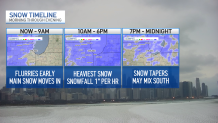
Around 8 a.m., Chicago's western counties will start to see the snow move in, NBC 5 Meteorologist Alicia Roman said, with snow picking up as the morning goes on.
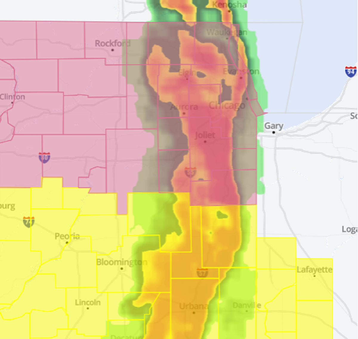
At 9 a.m., a winter weather advisory will go into effect for the entire Chicago area and Northwest Indiana, the National Weather Service said. The advisory is not set to expire until 3 a.m.
"If you don’t have the flexibility to stay home later today, plan ahead for much longer travel times," the NWS warned.
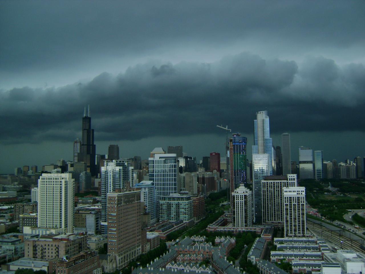
Between 10 a.m. and 6 p.m., heavy, steady snow was expected to fall, Roman said, with an inch of snow per hour possible. By around 6 p.m., the snow will gradually taper off, with some lingering flurries through midnight. South of I-80, a wintry mix with freezing drizzle was possible.
Afternoon and evening commutes were expected to be impacted.
(1/4) The first significant snow of the season is expected today, with significant impacts to travel, especially during the afternoon. If you don’t have the flexibility to stay home later today, plan ahead for much longer travel times. Take it slow when driving! #ILwx #INwx pic.twitter.com/M2Em7vERHi
— NWS Chicago (@NWSChicago) February 12, 2025
"The heavier, more impactful snow will last around 4-6 hours in any given location," the NWS said, "Resulting in quickly deteriorating travel conditions."
How much snow will we get and where?
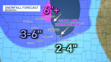
On average, the majority of the Chicago area can expect to see between four and five inches of snow, NBC 5 Meteorologist Kevin Jeanes said.
South of I-80, where temperatures will be warmer, between two and four inches of snow was possible, along with a wintry mix and freezing rain.
The "bullseye" spot with the highest snow totals of around six inches or even more was northern Lake County, Jeanes said, just south of Waukegan and into Milwaukee.
According to the NWS, a winter storm warning was in effect beginning at 12 p.m. Wednesday for southern Wisconsin including Waukesha, Milwaukee, Racine and Kenosha, with total snow accumulations between five and nine inches possible.
"Travel could be very difficult," the NWS warned. "The hazardous conditions could impact the Wednesday evening commute."
Another snow system ahead
Wednesday's system is the first of two rounds of snow expected this week, Roman said.
While Thursday into Friday morning will be dry, snow will develop again Friday afternoon and evening, Roman said.
"Right as the afternoon and evening commute gets underway," Roman said, of the timing. "Continuing all night long and into Saturday morning."
That system could result in an additional two to five inches of snow accumulation, Roman said.
After that, temperatures turn much colder, with highs in the 20s and teens, Roman added.