
Following an evening of tornado and thunderstorm warnings, more chances for strong-to-severe storms and extreme heat and humidity were in Chicago's Monday forecast, the NBC 5 Storm Team said.
"The storms could certainly pack a punch, just like we saw last night," NBC 5 Meteorologist Alicia Roman said.
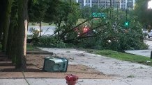
Sunday evening's storms left downed trees and power lines for some, and multiple areas remained without power Monday morning. As of 7 a.m., according to ComEd's outage map, more than 15,000 customers had power outages.

In Chicago, a downed tree was blocking a lane on southbound DuSable Lake Shore Drive at Jackson Boulevard.
More chances for strong-to-severe weather
Local


While Monday's daytime hours were expected to be dry, another round of strong-to-severe storms could move in from the west beginning around 5 p.m., Roman said, with a small chance of an isolated storm in the area around 3 or 4 p.m.
According to Roman, the storms were likely to begin in the far western part of the state. By around 8 or 9 p.m., those storms were expected to move into the Chicago area.
Feeling out of the loop? We'll catch you up on the Chicago news you need to know. Sign up for the weekly Chicago Catch-Up newsletter.
According to National Weather Service, the Chicago area was at an "enhanced" risk of severe weather Monday, which ranks as level three of five on the Storm Prediction Center's severe weather scale. The greatest threat Monday's storms carry are damaging winds. However, large hail and the chance for tornadoes were also possible, the alert said.
Additionally, "torrential" downpours may cause flash flooding," the alert said.
Storms were expected to move into Northwest Indiana by around 10 p.m., Roman said, with storms expected to end around 1 p.m.
Heat advisory goes into effect
Monday will also see a hot day Roman said, with high temperatures in the 90s and even higher heat indices.
"Most locations in the low-to-mid 90s," Roman said. "That's tolerable. What's not tolerable is the extreme humidity," Roman said.
According to Roman dewpoints Monday were expected to be between 70 and 75 degrees. Those high humidity levels would result in "feels-like" temperatures between 100 and 110 degrees. Areas to the west and southeast of Chicago were expected to see the highest heat indices.
Chicago to open cooling centers Monday, feels-like temps near 110 degrees possible
Beginning at 8 a.m., a heat advisory will go into effect for DeKalb, LaSalle, Kendall, Grundy, Northern Will and Kankakee Counties, the NWS said in an alert.
"Hot temperatures and high humidity may cause heat illnesses to occur," the alert said. "Drink plenty of fluids, stay in an air-conditioned room, stay out of the sun, and check up on relatives and neighbors."
According to the NWS, the advisory was scheduled to expire at 7 p.m. Monday.
A full forecast for the Chicago area this week can be found here.