
Winter weather is on its way to the Chicago area, with rain and snow moving in Thursday afternoon set to create a potentially challenging and hazardous evening commute, especially for parts of Northern Illinois where a winter weather advisory will soon take effect.
According to the National Weather Service, a winter weather advisory for 3 p.m. Thursday has been issued for McHenry, Kane and Northern Cook Counties, lasting until 7 a.m. Friday. Lake, DuPage and Central Cook Counties are also under a winter weather advisory, beginning at 6 p.m. Thursday until 10 a.m. Friday.
According to the NWS, the advisory went into effect in DeKalb county around 11:30 a.m.
According to the NBC 5 Storm Team, the system making its way in from the east is expected to bring accumulating, wet snow to parts of the Chicago area, with heavier snowfall and higher snow totals expected close to the Illinois-Wisconsin border.
However, in counties along Interstate 80 and Interstate 88, and far southern counties, the system will bring mostly rain, forecast models show, with a potential sharp cut-off of snow across Northern Cook County.
Here's a breakdown from the NBC 5 Storm Team of when and where the system is expected to roll in, and how much snow the Chicago area could see.
Local


Storm Timeline
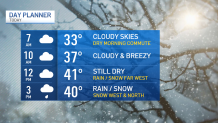
According to the NBC 5 Storm Team, Thursday morning remains dry, and temperatures are expected to hover in the upper 30s to low 40s.
Feeling out of the loop? We'll catch you up on the Chicago news you need to know. Sign up for the weekly Chicago Catch-Up newsletter.
Forecast models show the wintery system is expected to move into the area beginning around 2 p.m. in DeKalb and McHenry Counties, with precipitation likely in the form of snow.
By 5 p.m., the NBC 5 Storm Team says, the rain is expected to transition to snow to the north. In far southern counties like Kankakee, precipitation is likely to stay in the form in rain, the NBC 5 Storm Team says.
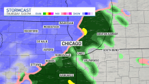
Later in the evening, around 8 p.m. a mix of rain and snow is possible across much of the Chicago area, with wet, accumulating snow closer to the Illinois-Wisconsin border.
According to the National Weather Service, the worst conditions for Northwest Illinois are expected between through the evening commute, between 6 p.m. and midnight, while the worst conditions for Northeast Illinois are likely to occur later, between 8 p.m. and 2 a.m.
"Snow rates are likely to peak near one inch per hour early this evening," an alert from the NWS says. "The expected heavy, wet nature of the snow will make shoveling hazardous."
Additionally, untreated roads could make travel difficult, particularly during the times when the heaviest snow is expected to fall, the NWS says.
According to the NBC 5 Storm Team, just before midnight, most areas with rain are expected to transition to snow, with scattered snow showers continuing overnight, setting up a potentially slick and slippery commute Friday morning.
How Much Snow Could Fall?
According to the NBC 5 Storm Team, snowfall will likely depend on temperatures. As of early Thursday, the NBC 5 Storm Team says highs are expected to remain in the upper 30s to low 40s.
"Above-average freezing temperatures will initially result in some melting, but higher snowfall rates (up to one inch per hour) will result in accumulations on roadways this evening," the NWS says.
According to forecast models, snow totals between three and six inches is likely in Lake and McHenry, as well as Northern DeKalb and Kane Counties, with potentially higher totals near the Illinois-Wisconsin border.
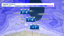
In DuPage and Central and Northern Cook Counties, where a rain-to-snow transition is expected, snowfall accumulations ranging from two-to-four inches is expected.
To the south, in Kankakee county and in parts of Northwest Indiana, less than an inch of snow is expected, as precipitation is likely to stay in the form of rain. However, Lake and Porter counties in Indiana could see between one and three inches, the NBC 5 Storm Team says.
Areas with snow will likely stick around through early Friday morning, with some scattered snow showers still possible at that time.