
Alicia Roman has the latest forecast with a winter weather advisory in effect.
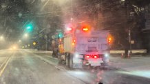
Chicago's first major winter storm of the season is here, with as much as six inches of snow possible in some parts, dozens of Illinois schools closed and significant travel impacts expected.
Live radar: Track snow, road conditions across the Chicago area as storm arrives
As of 5 a.m. Wednesday, a light flurries were flying across Lake and Northern Cook Counties, NBC 5 Meteorologist Alicia Roman said, with salt trucks passing through local roads. But the main snow event was still positioned out across Iowa, Kansas and Missouri.
Around 8 a.m., Chicago's western counties will start to see the snow move in, Roman said, with snow picking up as the morning goes on.
At 9 a.m., a winter weather advisory will go into effect for the entire Chicago area and Northwest Indiana, the National Weather Service said. The advisory is not set to expire until 3 a.m.
‘Don't be fooled:' Illinois road conditions expected to worsen as snow storm arrives
Local
"Snow chances really ramp up and stay that way through the afternoon," Roman said. "Expect a four-to-six hour period of non-stop snow."
(3/4) Here is a look at the timing of the highest snowfall rates which could last around 4 to 6 hours in any given location. This is when we expect quickly deteriorating travel conditions! #ILwx #INwx pic.twitter.com/ZHLGtKS5Lj
— NWS Chicago (@NWSChicago) February 12, 2025
Feeling out of the loop? We'll catch you up on the Chicago news you need to know. Sign up for the weekly Chicago Catch-Up newsletter.
Snow timing: When, what time will the weather be the worst?
One inch of snowfall per hour is possible in the afternoon, Roman said, with afternoon and evening commutes expected to be impacted, with slush-covered roads, reduced visibility and gusty winds.
"If you don’t have the flexibility to stay home later today, plan ahead for much longer travel times," the NWS warned.
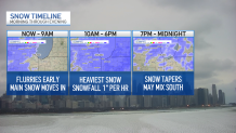
Between 10 a.m. and 6 p.m., heavy, steady snow was expected to fall, Roman said. By around 6 p.m., the snow will gradually taper off, with some lingering flurries through midnight. South of I-80, a wintry mix with freezing drizzle was possible.
"The heavier, more impactful snow will last around 4-6 hours in any given location," the NWS said, "Resulting in quickly deteriorating travel conditions."
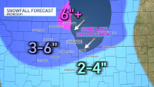
How much snow will we get and where?
On average, the majority of the Chicago area can expect to see between four and five inches of snow, NBC 5 Meteorologist Kevin Jeanes said.
South of I-80, where temperatures will be warmer, between two and four inches of snow was possible, along with a wintry mix and freezing rain.
The "bullseye" spot with the highest snow totals of around six inches or even more was in northern Lake County, Jeanes said, just south of Waukegan and into Milwaukee.
According to the NWS, a winter storm warning was in effect beginning at 12 p.m. Wednesday for southern Wisconsin including Waukesha, Milwaukee, Racine and Kenosha, with total snow accumulations between five and nine inches possible.
"Travel could be very difficult," the NWS warned. "The hazardous conditions could impact the Wednesday evening commute."
Another snow system ahead
Wednesday's system is the first of two rounds of snow expected this week, Roman said.
While Thursday into Friday morning will be dry, snow will develop again Friday afternoon and evening, Roman said.
"Right as the afternoon and evening commute gets underway," Roman said, of the timing. "Continuing all night long and into Saturday morning."
That system could result in an additional two to five inches of snow accumulation, Roman said.
After that, temperatures turn much colder, with highs in the 20s and teens, Roman added.