
Alicia Roman has the latest forecast with a winter weather advisory in effect.
Editor's Note: A ground delay will go into effect at 12 p.m. O'Hare International Airport due to weather.
Chicago's first major winter storm of the season is expected to dump heavy snow across the area beginning Wednesday morning, with more than 100 schools closed and roads expected to be snow and slush covered in the afternoon and evening.
As much as six inches of snow could fall, the NBC 5 Storm Team said, with higher totals expected across Lake County and into southeastern Wisconsin.
Beginning at 12 p.m., a ground delay went into effect at O'Hare International Airport, an alert from the Federal Aviation Administration said. It was expected to last until Wednesday afternoon. As part of the alert, departures to O'Hare would be delayed an average of 90 minutes due to snow or ice, the alert said. Real-time delays and cancellations can be found here.
In advance of the storm, the Illinois Tollway urged drivers to slow down and increase their distance from other vehicles as the snow moved in. Stranded motorists should turn on their emergency lights, remain in their vehicles and dial *999 for motorist assistance if needed, officials said.
Check the Illinois road conditions near you:
Nearly 200 plows will be deployed across the state to spread salt and de-icing materials, the Tollway said. In Chicago alone, a fleet of more than 300 snow vehicles are "fully prepared to respond if needed."
Local
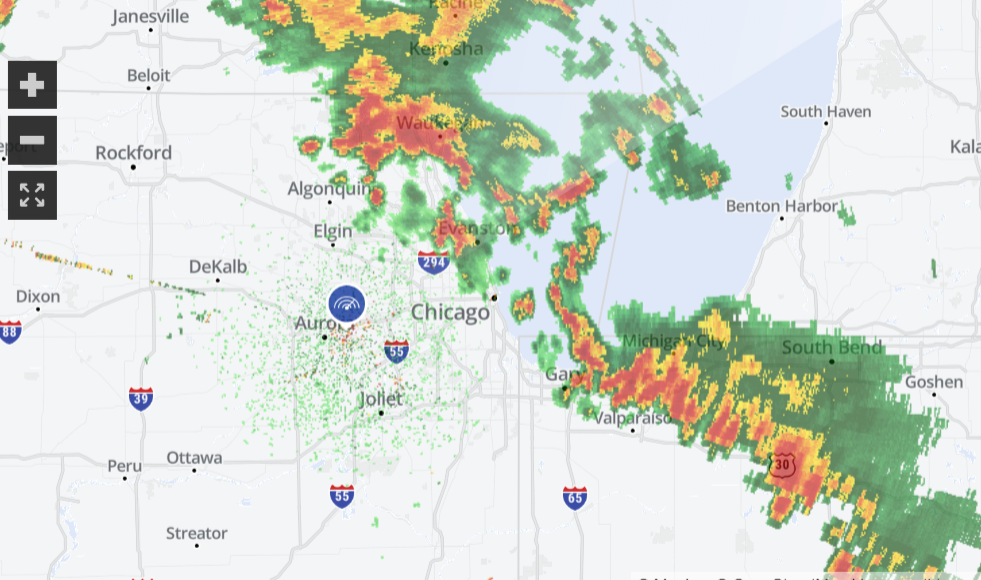
At 1 p.m., the National Weather Service posted a message to X, the platform formerly know as Twitter, saying that most roads around Northern Illinois were "at least partially snow-covered."
Feeling out of the loop? We'll catch you up on the Chicago news you need to know. Sign up for the weekly Chicago Catch-Up newsletter.
"Expect hazardous travel conditions to persist into tonight," the NWS said.
IDOT is reporting that most roads around northern IL have become at least partially snow-covered. Expect hazardous travel conditions to persist into tonight. Find roadway information for Illinois at https://t.co/365NygfTuR, and for Indiana at https://t.co/i1bZr4u59i. #ILwx #INwx pic.twitter.com/gq3R2zLyLz
— NWS Chicago (@NWSChicago) February 12, 2025

Before the snow moved in, roads were slick but not snow-covered, with Illinois road conditions expected to worsen as the day goes on.
"Don't be fooled by this morning's commute," Illinois Department of Transportation spokesperson Maria Castaneda said Wednesday morning.
Castaneda also warned that bridges, ramps, overpasses and intersections could be a lot more slippery than they appeared, and advised drivers to leave distance between vehicles.
"It's not about driving through it, it's about being able to stop in it," Castaneda said.
At 9 a.m., a winter weather advisory went into effect for the entire Chicago area, with snow moving into the region's far western counties. Between 10 a.m. and 6 p.m., heavy snow was expected to fall, with rates of up to an inch per hour.
"Expect a four-to-six period of nonstop snow," NBC 5 Meteorologist Alicia Roman said.
Snow timing: When, what time will the weather be the worst?
One inch of snowfall per hour is possible in the afternoon, Roman said, with afternoon and evening commutes expected to be impacted, with slush-covered roads, reduced visibility and gusty winds.
"If you don’t have the flexibility to stay home later today, plan ahead for much longer travel times," the NWS warned.
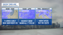
Between 10 a.m. and 6 p.m., heavy, steady snow was expected to fall, Roman said. By around 6 p.m., the snow will gradually taper off, with some lingering flurries through midnight. South of I-80, a wintry mix with freezing drizzle was possible.
"The heavier, more impactful snow will last around 4-6 hours in any given location," the NWS said, "Resulting in quickly deteriorating travel conditions."
How much snow will we get and where?
On average, the majority of the Chicago area can expect to see between four and five inches of snow, NBC 5 Meteorologist Kevin Jeanes said.
South of I-80, where temperatures will be warmer, between two and four inches of snow was possible, along with a wintry mix and freezing rain.
The "bullseye" spot with the highest snow totals of around six inches or even more was in northern Lake County, Jeanes said, just south of Waukegan and into Milwaukee.
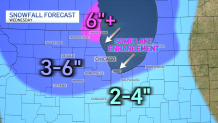
According to the NWS, a winter storm warning was in effect beginning at 12 p.m. Wednesday for southern Wisconsin including Waukesha, Milwaukee, Racine and Kenosha, with total snow accumulations between five and nine inches possible.
"Travel could be very difficult," the NWS warned. "The hazardous conditions could impact the Wednesday evening commute."
Another snow system ahead
Wednesday's system is the first of two rounds of snow expected this week, Roman said.
While Thursday into Friday morning will be dry, snow will develop again Friday afternoon and evening, Roman said.
"Right as the afternoon and evening commute gets underway," Roman said, of the timing. "Continuing all night long and into Saturday morning."
That system could result in an additional two to five inches of snow accumulation, Roman said.
After that, temperatures turn much colder, with highs in the 20s and teens, Roman added.