Update: As of Thursday morning, the latest snowfall projections and timing of the storm can be found here. Our Wednesday story continues below.
With a winter storm warning in effect for the northern suburbs, we’re learning more about the track of the inclement weather, and how much snowfall could potentially fall in the region.
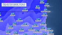
That warning is in effect for McHenry and Lake counties, and new model guidance from the NBC 5 Storm Team indicates that some higher-snowfall totals could occur, with 5-to-7 inches of accumulation by the time the storm leaves the area:
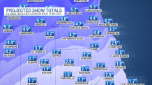
Most of the western suburbs are under a winter weather advisory on Thursday, as is the city of Chicago and all of Will County.
Those areas will see lower levels of accumulations, but anywhere from 2-to-4 inches of snow could fall, with higher totals north and northwest of the city of Chicago.
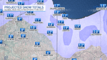
Areas to the south of Interstate 80 will be under a winter weather advisory, but new model guidance suggests that many areas could see more impacts from mixed precipitation than snow. In fact, many areas south of the interstate could struggle to even see an inch of accumulation.
A lake-effect band that was projected to impact northwestern Indiana may not develop on Thursday, but Lake County could still see 1-to-2 inches of accumulation from the snowfall.
Feeling out of the loop? We'll catch you up on the Chicago news you need to know. Sign up for the weekly Chicago Catch-Up newsletter.
For all the latest details, download the NBC Chicago app, or tune into the NBC 5 News.