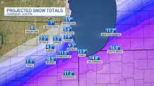
With two rounds of snow coming to the Chicago area, sparking winter storm warnings across several counties, some locations could see more than a foot of snow in 48 hours, but others may see far less.
Tuesday night and into Wednesday will bring the biggest snowfall of the systems set to hit the area this week.
Rain will likely change to snow shortly after sunset Tuesday as temperatures begin to drop. Snow is expected to then develop over the entire Chicago area, staying heaviest to the south and lightest to north.
LaSalle, Grundy, DuPage, Kendall, as well as parts of Cook and Will counties will be under a winter storm warning from 8 p.m. Tuesday through 6 p.m. Thursday, the National Weather Service announced.
Kankakee County, along with Lake, Porter, Newton and Jasper counties in Indiana, will be under a winter storm warning starting at 10 p.m. Tuesday and continuing through 6 p.m. Thursday. A separate warning takes effect at midnight for LaPorte County and goes until 6 p.m. Thursday.
A winter weather advisory also begins for parts of Cook, DeKalb and Kane counties at 8 p.m. Tuesday and continues through 6 p.m. Wednesday.
The heaviest snowfall will likely occur on Wednesday morning, with a snowfall rate of up to 1 inch per hour falling during that time for many locations. That will likely cause serious travel issues throughout the region, according to forecast models, and residents are urged to postpone unnecessary travel.
By Wednesday afternoon, the snow is expected to taper to light snow or flurries, but may not entirely end as the first wave moves out.
Local
Feeling out of the loop? We'll catch you up on the Chicago news you need to know. Sign up for the weekly Chicago Catch-Up newsletter.
NBC 5 Storm Team meteorologists say snow totals will vary dramatically across the area.
In the first storm, anywhere from 4 to 9 inches is possible for the metro area, while up to 14 inches could be seen in far southern suburbs and parts of northwest Indiana.
In northern suburbs, 1 to 3 inches is expected.
Another system could follow closely behind the first wave Wednesday evening and into Thursday, again largely for areas south of Chicago and in northwest Indiana.
This system could continue to dump several additional inches of snow in some locations through Thursday afternoon, before coming to an end by the evening hours.
If the second storm follows a similar path to the first storm, which is likely, far southern counties may receive 15 inches or more in total by Thursday night, though those totals don't account for compaction, which could make on-the-ground totals appear less.
Meanwhile, far northern counties will likely receive 1 to 3 inches or less by the time both systems move out.
For areas along Interstate 80, totals look to stay between 5 and 10 inches.
The winter storm warning for LaSalle, Grundy, Will, and parts of Cook County warns of 5 to 11 inches possible through Wednesday, though additional snow may fall outside of the warning window. In DuPage and Kendall, the warning calls for anywhere from 4 to 8 inches of snow.
In Kankakee County in Illinois and Newton, Jasper, Lake and Porter counties in northwest Indiana, the warning calls for accumulations between 8 and 12 inches with the first system and an additional 3 to 6 inches from Wednesday night through Thursday.
The advisory for DeKalb, Kane and northern Cook County calls for total accumulations between 1 and 5 inches of snow.

The National Weather Service says that travel may become “very difficult-to-impossible” during these snow systems and residents are being urged to postpone any unnecessary travel.
The Illinois Department of Transportation warned of "treacherous conditions" expected for several days, "with the potential for extremely dangerous and, at times, life-threatening travel across much of the state."
The NBC 5 Storm Team will continue to monitor the weather systems as they develop, and the latest information can always be found on the NBC Chicago app.


