Kevin Jeanes has the latest as potentially severe storms eye the Chicago area ahead of possible snow.
EDITOR'S NOTE: Track strong to severe storms as they head to the Chicago area Wednesday here. As of 12:20 p.m. a tornado watch was in effect for multiple counties in Illinois and Indiana until 9 p.m. Our original story continues below.
Severe weather chances loomed over the Chicago area for the final day of winter, with tornadoes, damaging winds, thunderstorms and hail all possible, followed by snow to kick off the first day of spring.
While weather conditions Wednesday morning started out quiet, a system moving in from the west would begin to move in by mid-morning.
As the weather moves in, here's a timeline of what to expect and when.
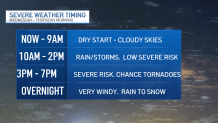
Wednesday morning, early afternoon: Storms move in
Wednesday morning would be cloudy and dry through 9 a.m., NBC 5 Storm Team Meteorologist Alicia Roman said, with a wide temperature range of 30-degree readings to the north, 50-degree readings in the south, and temperatures in the 40s in between.
Later Wednesday, the wide range of temperatures would continue, with temperatures to the south reaching into the 60s while other spots will remain in the 40s.
Between 10 a.m. and 2 p.m., rain and storms were expected to move in, though severe weather was not expected during that time, Roman said.
After 2 p.m. however, better chances of severe weather were likely.
Feeling out of the loop? We'll catch you up on the Chicago news you need to know. Sign up for the weekly Chicago Catch-Up newsletter.
Wednesday afternoon: 'All weather hazards at play'
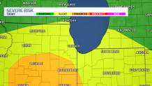
Between 3 p.m. and 7 p.m., the Chicago area will see the greatest chances for severe weather, Roman said, with conditions expected to hit the city around 6 p.m. At that time, most parts will be at a level two of five, or "slight" risk, of severe weather on the Storm Prediction Center's scale.
Areas to the south though, including parts of Grundy, LaSalle and Kankakee Counties, will be at a level three or "enhanced" risk Roman said.
"All weather hazards will be at play," Roman said, including hail, tornadoes, and strong, damaging winds.
According to the National Weather Service, tornadoes were especially possible along and south of I-88.
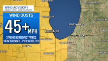
Wednesday night: Wind advisory
By around 8 p.m., any lingering rain will gradually transition into snow showers, with snow expected to continue overnight.
Beginning at 10 p.m., a wind advisory will go into effect for all of Northeast Illinois, with winds upwards of 45 miles per hour possible.
"Tree limbs could be blown down and a few power outages may result," the NWS warned, adding that "wind-whipped snow" Wednesday evening could lead to poor visibility and hazardous travel.
Thursday morning: Snow
The first full day of astronomical spring will start out snowy and blustery, Roman said, with light snow expected to continue through around 6 a.m. as the wind advisory continues.
By around 7 a.m., the system was expected to move out, leaving behind as much as two inches of snow for some.
"There may be some slushy, wet roads early Thursday morning," Roman said.
Temperatures Thursday will start out in the 30s, reaching into the 40s by afternoon. Friday, temperatures would warm back up into the 50s, though they'll dip back down by Saturday.