Editor's note: Find the latest updates on the approaching snowstorm here.
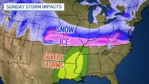
A major winter storm is slated to wallop a large swath of the U.S., dumping heavy snow from Kansas to Maryland and bringing some regions what could be the heaviest snowfall in more than a decade.
Midwest states, including Illinois, will likely be in the middle of the action as the "disruptive" winter storm moves eastward through the weekend and into early next week, causing major travel impacts, blizzard conditions and the potential for significant ice, according to the National Weather Service.
"Impacts will start in the Central Plains by late Saturday, then across the Ohio Valley on Sunday where severe travel disruptions are expected," the NWS said on X, the social media platform previously known as Twitter. "The storm will then track into the Mid-Atlantic Sunday night and into Monday."
Current forecast models show as much as 12 inches of snow accumulation in portions of West Central Illinois, where a winter storm warning is set to take effect late Saturday. According to NWS, rapid snow accumulation could make travel "very difficult to impossible" in a 17-county area including Quincy, Pittsfield and Edwardsville, beginning at 10 p.m. through 6 a.m. Monday morning.
Meteorologists urge people to "exercise extreme caution" -- if travel is necessary.
Local
The rest of Illinois, excluding roughly the northern third of the state, likely won't see as dangerous conditions -- although a winter storm watch remains in effect for a large stretch of the weekend. Expected snow totals vary widely across the central portion of the state, with values ranging between 0 and 12 inches, according to the NWS.
Similar conditions are expected in portions of North Central Indiana, just south of the NBC Chicago viewing area.
Feeling out of the loop? We'll catch you up on the Chicago news you need to know. Sign up for the weekly> Chicago Catch-Up newsletter.

While snow impacts will begin late Saturday in some states, a winter storm watch doesn't take effect for northern Indiana until Sunday evening. Heavy snow could bring accumulations of anywhere between 3 and 6 inches, the NWS said, urging drivers to prepare for slippery road conditions and blowing snow through the Monday evening commute.
Whether the Chicago area will be directly impacted remains yet to be seen.
If the storm tracks further north, it could clip parts of the region Sunday into Monday.
"There is a set of models keeping the system completely south of the Chicago area, and another set of models bringing up to 3 inches of snow for us; with more snow for the Kankakee River valley," NBC Chicago Meteorologist Kevin Jeanes said.
According to the latest NWS projections, anywhere between 0 and 4 inches of snow is possible in communities such as Kankakee and Pontiac.
Behind this storm, Arctic air will spill down from Canada and temperatures for much of next week will be well below average from the northern Plains to the Southeast, including in the Chicago area.


